The procedure for tracking and reporting helicopter flights on Waiheke Island is detailed below:
Please note that all the following examples were selected at random, by convenience, when writing this information. They are not given as examples of poor behaviour or rule-breaking
How to track & report helicopters
1. Go to www.flightradar24.com (you can also get the Flight Radar 24 app on your device)
2. If a helicopter has an ADS-B transponder installed and switched on, it will be visible on the real-time map as a little yellow helicopter shape, along with all other aircraft that have transponders on (aeroplanes have different shapes).
3. You can move the map around and zoom in and out, or centre it on your browser’s location by clicking on this icon at the bottom of the screen:
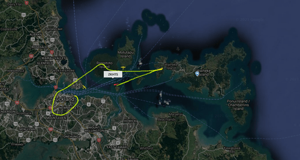
4. You can click directly on the helicopter as it moves across the map. This brings up a line showing its flightpath, like this:

5. It also brings up some information in the sidebar (this is an example)
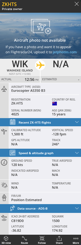
6. Clicking on ‘Recent ZK-*** flights’ (see above) will list recent flights for this helicopter, including the date, time, origin and destination.
Another way to access past flights is to use the search function and enter the aircraft identification ‘ZK-***’. Obviously, ‘***’ will be a different three-letter code, unique to each registered helicopter. This code should be displayed on the helicopter. Actually, ZK-H** and ZK-I** are the marks reserved for helicopters in New Zealand.
The searchable register is held here: https://www.aviation.govt.nz/aircraft/aircraft-registration/aircraft-register-search/
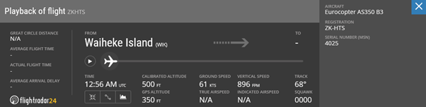
7. The past flights can be played back by clicking on the > Play button. Then the screen will show the full flightpath and below it will be a window:
If there’s a > Live button instead of a > Play button, then that just means that the flight is still in progress, but you can view it in the same way.
You can drag the plane icon (see below) to any point in the flight![]() and the helicopter will move along the flightpath on the screen above. When it is over the location of interest, you can note the altitude and time. You may want to take a screen grab, but it’s not essential if you have that information and the ZK-*** registration code. The Civil Aviation Authority will look your flight up using the same system (flightradar24.com).
and the helicopter will move along the flightpath on the screen above. When it is over the location of interest, you can note the altitude and time. You may want to take a screen grab, but it’s not essential if you have that information and the ZK-*** registration code. The Civil Aviation Authority will look your flight up using the same system (flightradar24.com).
8. There’s another ‘global’ playback function available on the website, which allows you to choose a particular area on the map, date and time to view tracked aircraft. You could look at a particular helipad, or at your property, or Waiheke in general. Click the icon below to access it.![]()
Note: The times are in UTC. To convert from NZ time, go here: https://savvytime.com/converter/nzdt-to-utc. Check the date doesn’t need to be changed. Then you can watch all the flights through the selected area for that period of time. You can change the speed of playback and drag the time back and forth on the bar.
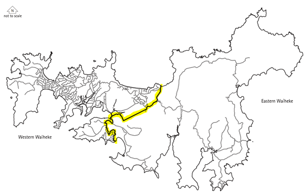
9. If the altitude is less than 1000ft over an area meeting the following description, then the helicopter may be below the minimum flight height.
Congested area in relation to a city, town or settlement means any area which is substantially in use for residential, industrial, commercial, or recreational purposes:
(from p39 of: https://www.aviation.govt.nz/assets/rules/consolidations/Part_001_Consolidation.pdf)
Clearly, this is most or all of the western end of Waiheke, and some parts of the eastern end.
For areas that are not substantially in use for residential, industrial, commercial or recreational purposes, the minimum height for overflight is 500ft.
Helicopters are allowed below the minimum overflight height (1000ft over western Waiheke) when taking off and landing, but given that helicopters can take off and land close to vertically, this should not be far from the helipad, if they are following the ‘Fly Neighborly’ guide (which many consents require them to follow).
10. It is important to note that the altitude figure given is an approximation of the elevation over sea level, however the overflight rules require that the aircraft is flown 1000ft (usually) over the highest obstacle in a 600m radius.
11. To get the elevation of the land, go to the same location in the Auckland Council GIS viewer: https://geomapspublic.aucklandcouncil.govt.nz/viewer/index.html. You can search by address or by scrolling and zooming (or by entering latitude and longitude or NZTM coordinates if you have them). You can select the aerial photo background by clicking the small circled icon, then the big one:
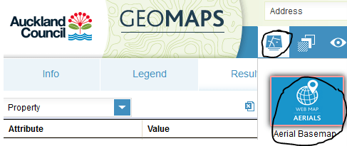
And you can put the contour lines on the map by clicking on Legend and then Contours:
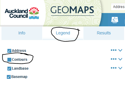
These things are all in the top left corner of the screen. The orange contour lines will show the ground level pretty accurately, in metres above sea level. The overflight height should be 1000ft over that. So, if the land is at 80m and there’s a 5m high building on it (and that is the highest obstacle), the starting height is 85m. Type ‘85m to ft’ into google and it tells you that it is 279ft (rounded to the nearest whole number). So, the helicopter should be flying at 1279ft over this point.
Remember that the 1000ft overflight height should be above the highest obstacle in a 600m radius. So, if there’s a 120m high peak, 500m away, that has a 20m high tree on it, the helicopter should be at a minimum height of 120m+20m+1000ft=1459ft.
12. With the free version of Flight Radar 24, there’s a week worth of past flights stored. With the Silver subscription there’s 90 day’s worth. And with the Gold subscription there’s a year’s worth. With the Gold subscription there are two altitudes given. See these articles to try to understand why they are both wrong:
https://pilotworkshop.com/tips/vfr_altitude_gps/
https://xcmag.com/news/gps-versus-barometric-altitude-the-definitive-answer/
In any case, it appears to be the barometric value which is mostly used.
13. To report a helicopter flight, click on the share button (the bottom of the sidebar shown in (5) above, which will bring up the following:
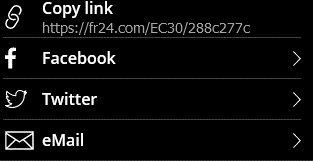
14. The copy link button will copy the text (in this case https://fr24.com/EC30/288c277c) which you can then paste the text into your complaint.
15. The Civil Aviation Authority (CAA) says:
“If there are concerns regarding an aircraft flying too low, and therefore in breach of the Civil Aviation Rules, then this should be reported to the Inward Safety Team at isi@caa.govt.nz. If the flight is legal but there are concerns that the operator is not taking enough care to reduce the noise for residents, then this should be referred to the Auckland Council.”
To complain to Auckland Council’s compliance department, go to the Auckland Council website and fill out an enquiry.
https://www.aucklandcouncil.govt.nz/report-problem/Pages/email-us.aspx
There is more information on the CAA website: https://www.aviation.govt.nz/safety/aviation-concerns/
And an online form to report aviation concerns (which can be completed anonymously):
https://www.aviation.govt.nz/about-us/contact-us/report-an-aviation-safety-concern/
16. Please send a copy of all complaints and responses to quietskywaiheke@outlook.com
17. Remember, only helicopters with their ADS-B transponders switched on will show on the map. Unfortunately, some helicopters do not have them, or do not switch them on, or indeed some have been observed to switch them off as they approach Waiheke or approach their landing area. Another issue is that some transponders do not broadcast the helicopter’s ZK-*** registration code. You can still get the flight information in this case, per (13) above, to submit in a report to the CAA. Quiet Sky Waiheke advocates that all helicopters should have full information transponders on at all times over Waiheke Island, to facilitate monitoring.
That’s it! Thank you for taking the time to help improve helicopter safety, reduce helicopter noise and reclaim our Quiet Sky on Waiheke Island 🙂